SiteMap® is your digital command center for infrastructure management. Built on a powerful Geographic Information System (GIS) foundation, SiteMap gives you a customizable interface to manage your facilities, utilities, and now your reality capture data.
From Underground to Aboveground, All in One Place
The industry has long trusted GPRS for underground utility locating services. GPRS Project Managers complete a utility scan with 99.8% accuracy and then upload the results to SiteMap. This gives you instant access to verified subsurface data.
SiteMap now takes infrastructure management to the next level with the the Reality Capture Layer. This lets you store and work with 2-4 mm accurate 3D laser scanning data. You can do this alongside your utility and sewer records. Whether you oversee a single site or many across the country, SiteMap keeps your data safe, organized, and accessible.
What is the SiteMap® Reality Capture Layer?
The Reality Capture Layer is your gateway to high-fidelity, geolocated 3D data. It’s designed to make working with complex spatial datasets intuitive and efficient. Whether you’re reviewing a scan from a recent renovation or planning a new build, SiteMap gives you the tools to visualize your site in detail.
What Deliverables Can You Access?
Point Cloud Data
Point clouds are raw spatial data. They come from 3D laser scanning services using LiDAR or photogrammetry. These dense collections of X, Y, and Z coordinates form the foundation for digital twins, BIM models, and CAD drawings.
SiteMap transforms these point clouds into actionable insights. Our Mapping & Modeling team can convert them into:
- 2D CAD drawings
- 3D models
- Interactive virtual walkthroughs
With SiteMap, you can zoom, measure, and analyze your point cloud data right in the platform. There’s no need to switch between multiple software tools.

The SiteMap® Reality Capture Layer lets you see detailed 3D laser scan data in an interactive way. This helps with accurate analysis and facility management.
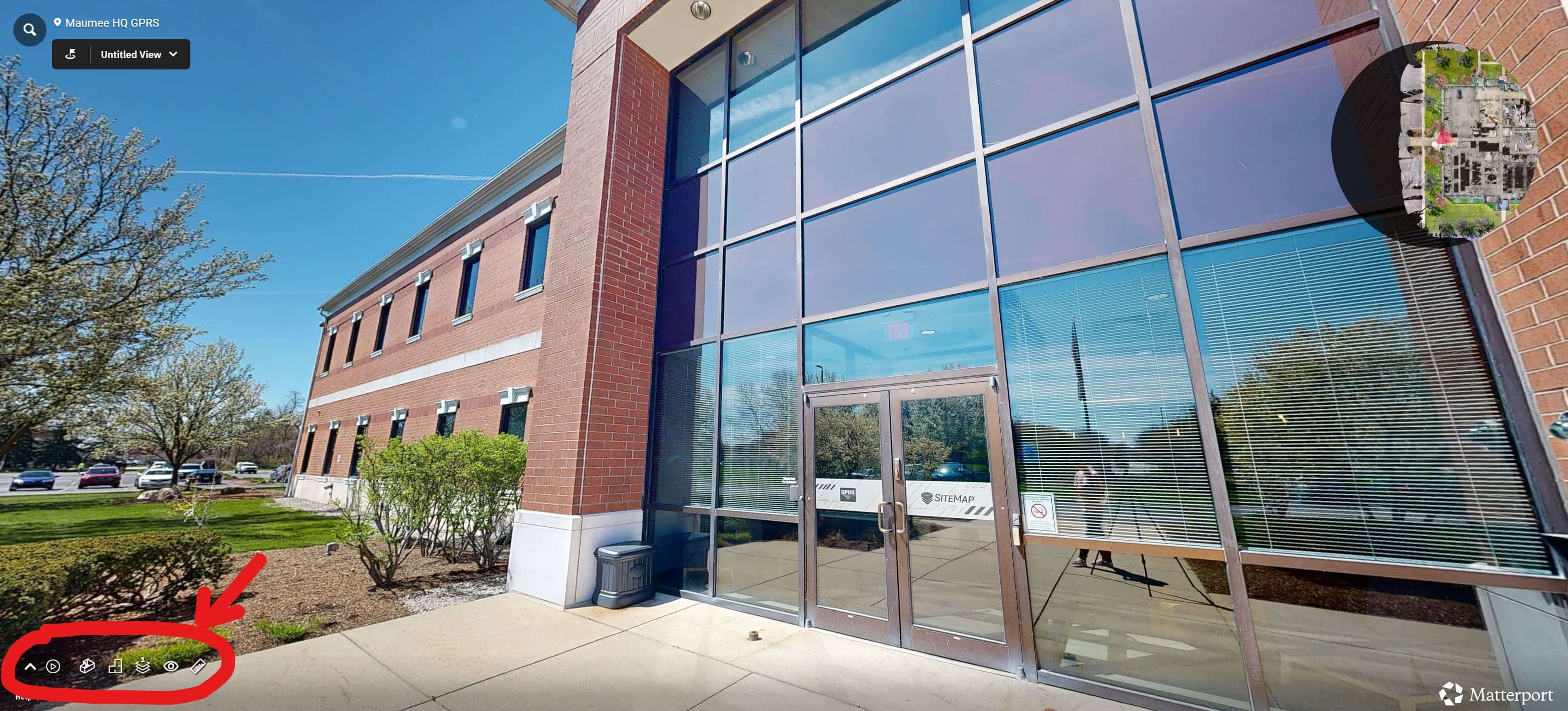
Virtual Walkthroughs
Using professional-grade 3D cameras, GPRS captures immersive 360° walkthroughs of your facility. These are interactive tools for collaboration, documentation, and decision-making.
Explore your site with:
- Dollhouse View: a full 3D model of your property
- Floor Selector: isolate and inspect individual floors
- Measurement Tools: take accurate measurements from any angle
- Bird’s-Eye Floor Plans: get a top-down view of your layout
Virtual walkthroughs are ideal for remote team coordination, emergency planning, and facility audits.
Virtual walkthroughs allow for enhanced collaboration across teams, more efficient project management, accurate documentation, and can even serve as emergency response guides.
Revit Models
SiteMap supports full integration with Autodesk Revit, the industry-standard BIM software. Once your model is uploaded, you can explore it using:
- First-person navigation
- Explode view (disassemble components)
- MEP, Civil, and Architectural views
- Topographical overlays
- Media browser to toggle model layers
This detail helps AEC professionals plan, design, and adjust with confidence.
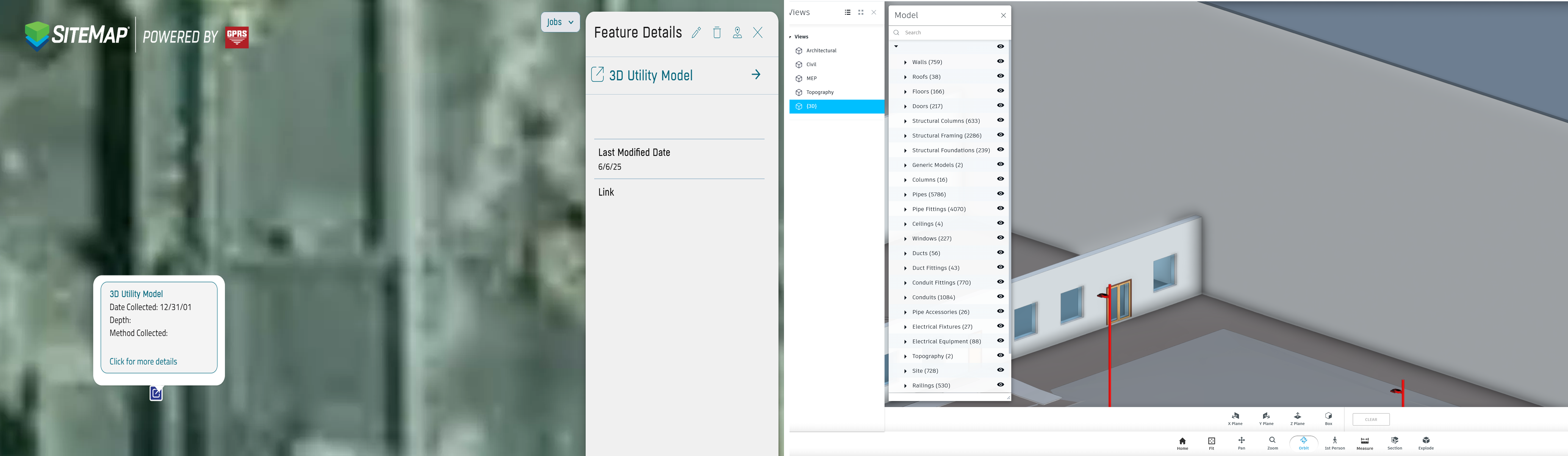
With the SiteMap® Reality Capture Layer, you can view geolocated 3D utility models alongside detailed Revit building components for complete visualization and data management.
The SiteMap® Advantage
GPRS Director of Reality Capture, Matt Mikolajczyk, shares what makes the SiteMap Reality Capture Layer stand out:
“It’s all in one place and it’s geolocated, so it’s on top of the building that it belongs to. With Google Drive, Procore, or Box, there are all these other file storage solutions you can put all in one place. Ours is different because it’s geospatially all in one place.”
This isn’t just about convenience, it’s about context. SiteMap uses advanced GIS mapping software to layer your reality capture data onto your site’s geolocation. Instead of digging through folders, you’re navigating your facility in an accurate digital environment. And unlike other platforms that require manual linking or data management, SiteMap delivers a fully integrated experience:
“I think there are other tools like SiteMap, but for a lot of those tools, they still rely on the end user to link them into the platform. That’s another benefit. We do that as part of our service. We put [your as-built information] in this platform for them, so they don’t have to manage it. They can just get in and use it.”
That’s the SiteMap difference. Interactive, software solutions that make your data usable, shareable, and actionable from day one.
How to Use the Reality Capture Layer
Getting started is simple. Once you log in to the SiteMap, you’ll find the Reality Capture Layer in the toolbar on the left-hand side.
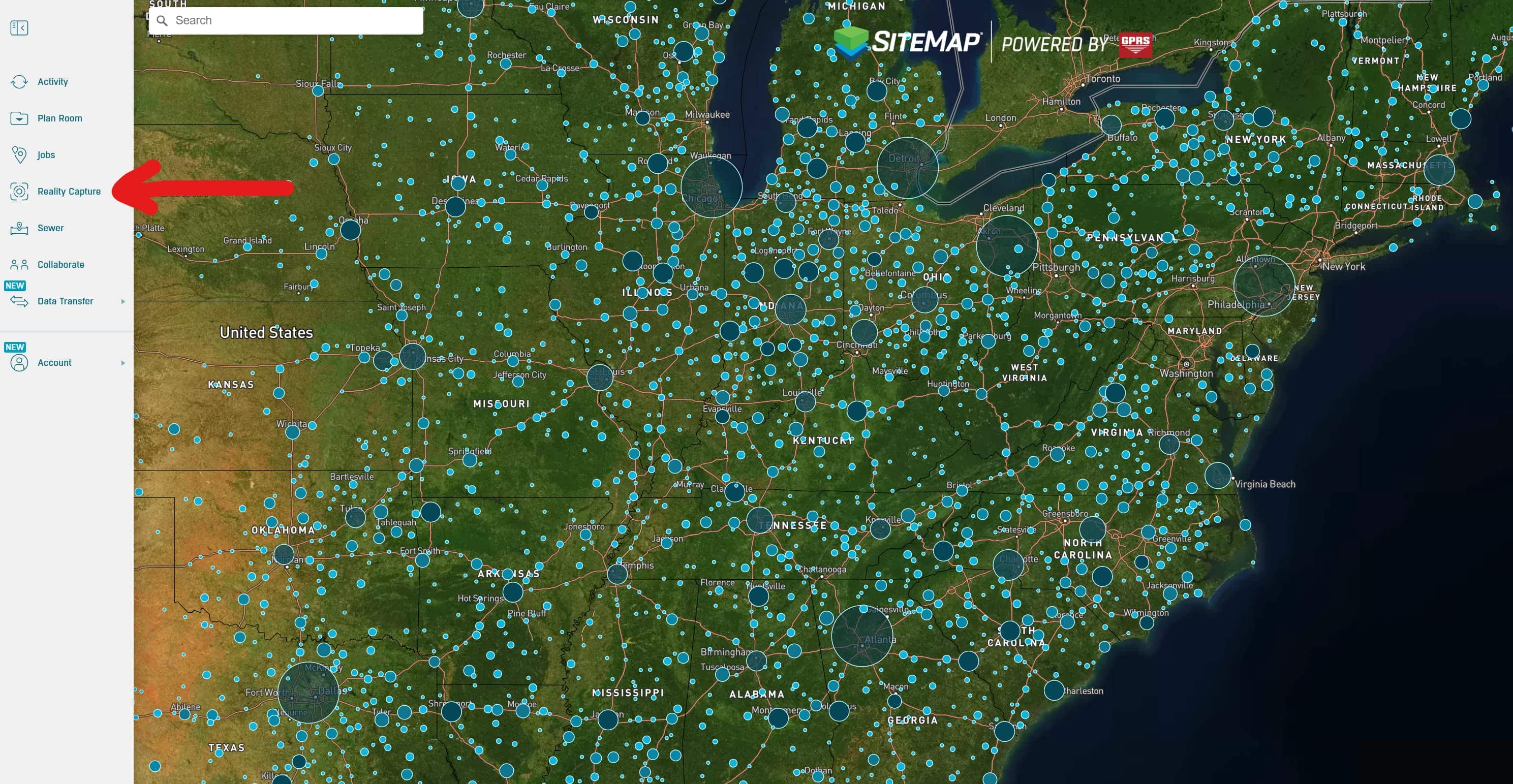
To locate your job, you can:
- Enter your Work Order Number (WO#) or company name in the Reality Capture Layer search bar
- Enter the site address in the main search bar

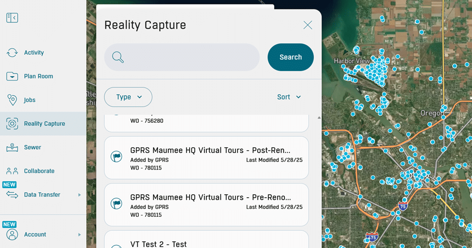
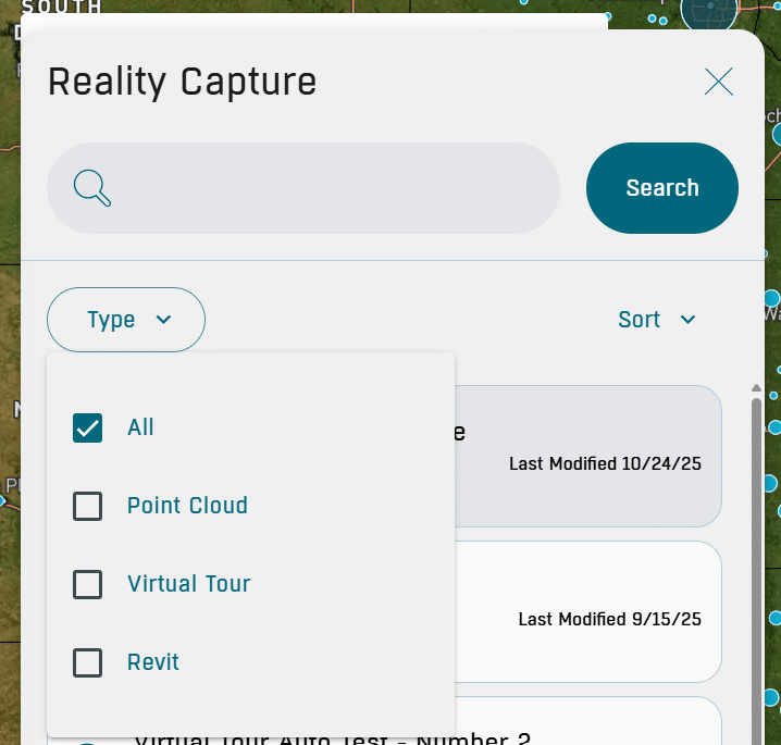
If you search by WO#, you’ll have the option to filter by deliverable type, including:
- Point Cloud
- Virtual Tour
- Revit
When your data appears, you can analyze it directly inside SiteMap. There is no need to switch between platforms or file types.
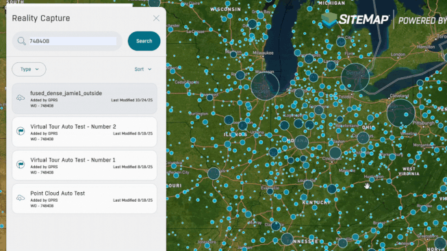
If you search by address in the main search bar, the map will take you to the site’s geolocation. Icons above the structures indicate available deliverables:
 Point Cloud Data
![]() Virtual Walkthroughs
Virtual Walkthroughs
![]() Revit Models / External Links
Revit Models / External Links
Having all your data in one spot can speed up projects. It makes decisions easier and helps prevent expensive rework.
Seamless Integration, Immediate Access
SiteMap Reality Capture is designed to serve your needs. GPRS clients with Project, Pro, or Team access receive their reality capture data in SiteMap when scanning and modeling are complete.
If your past projects involved 3D laser scanning or reality capture services, we can add those deliverables to your SiteMap dashboard. This way, you’ll get a complete, geolocated view of your built environment.
With SiteMap, your data becomes a tool. The Reality Capture Layer helps you make informed decisions. It simplifies collaboration and ensures accurate records at every stage of your facility’s lifecycle.
Take control of your facility by taking control of your reality with SiteMap.
Click below to schedule your free SiteMap demo!
FREQUENTLY ASKED QUESTIONS
How do I export data from SiteMap?
Exporting is simple. From your Digital Plan Room or Map Viewer, you can download files in formats like DWG, PDF, or orthophotos. This lets you take interactive maps and records from SiteMap into CAD, GIS, or other software without disrupting your workflow.
Can SiteMap scale as my portfolio grows?
Yes. SiteMap was created to accommodate scalability. Whether you oversee a single facility or a nationwide portfolio, the platform merges your data into one interactive system. You can keep adding new projects using the same workflow. This lets you expand without changing your process.
How secure are my records in SiteMap?
SiteMap uses a cloud-based setup with controlled access permissions, so your data stays safe and recoverable. All files, maps, and attachments are stored in one central location. This makes collaboration simple and cuts the risk of losing data.