Utility Locating for Power Plant Security Fence Installation
When a nuclear power plant plans to install a new security fence, accuracy beneath the surface matters just as much as the precision above it.
At a power plant on the coast of Lake Michigan, a general contractor required verified underground utility locations across dozens of targeted areas to safely construct a new security fence. This included planning for auger fence posts, surface set concrete blocks, and hydro excavated footers, all of which needed to be installed without causing utility strikes, service outages, or security incidents.
GPRS Project Summary
GPRS partnered with the power plant’s general contractor to provide utility locating and mapping to support the design and installation of a new security fence. This project required locating and mapping of dozens of work areas. GPRS delivered field validated digital maps that helped to keep the project safe, compliant, and on schedule.
Objective: Support installation of a new security fence by locating and mapping public and private underground utilities across multiple work areas.
Scope: Clearances for 30 areas in preparation for 4 ft. x 4 ft. concrete block installation; 2 areas planned for hydro excavated footers, plus 4 locations to check for buried concrete at fence posts.
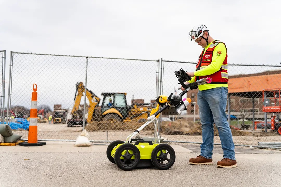
Technologies: Ground penetrating radar (GPR) and electromagnetic (EM) locating technology was used to identify all public and private utilities, including metallic and non metallic lines.
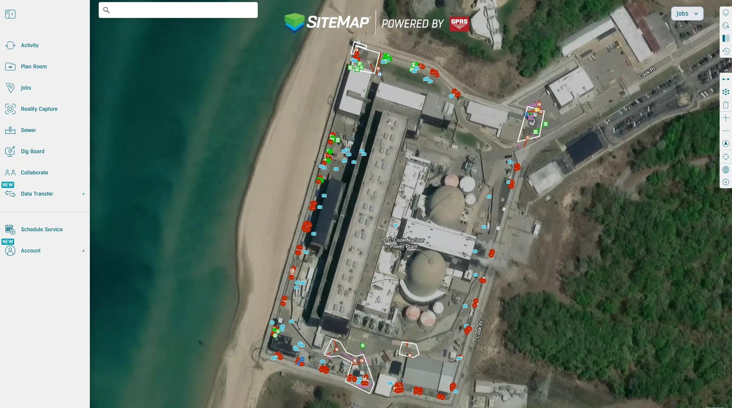
Deliverables: Utilities were clearly marked on the surface using paint, flags, and other appropriate indicators. All findings were captured via GPS and delivered through SiteMap®, GPRS’ GIS platform, as CAD/PDF maps along with KMZ and SHP file exports.
GPRS partnered with the power plant’s general contractor to provide utility locating and mapping to support the design and installation of a new security fence.
When you have an accurate building map, accessible 24/7, teams can quickly see what is underground, avoid costly surprises, and keep people safe.
The Challenge
Security fencing at a nuclear power plant is subject to strict federal regulations designed to prevent unauthorized access, maintain continuous operations, and protect vital equipment.
According to the United States Nuclear Regulatory Commission (NRC), the security fencing at nuclear power plants requires a high-security, multi-layered perimeter designed to detect, delay, and defend, typically involving two 8-foot chain-link fences topped with barbed wire, separated by a sterile, monitored “no man’s land” isolation zone. These barriers must meet NRC regulations in 10 CFR 73.55.
Security barrier enhancements are often driven by intelligence updates and regulatory requirements. The NRC states that work near or within these zones must be planned to avoid creating vulnerabilities or triggering alarms.
Before any drilling or excavation takes place, thorough subsurface due diligence is essential to safeguard the power plant. Because private utilities at power plants are not typically marked by 811, the site may contain high voltage feeders, water and storm lines, communication pathways, and other specialized plant systems that must be identified and mapped before work begins. Hiring a private utility locator is a critical step to prevent accidental damage to critical infrastructure during the installation of security barriers, because even a single utility strike can jeopardize safety, disrupt operations, and trigger compliance violations.
Nuclear power plants also follow strict, multi layered personnel access authorization protocols to verify identity and ensure only qualified individuals enter secure areas. This process includes REAL ID–compliant identification, comprehensive background checks, including fingerprinting, criminal history, credit review, and employment verification and approval only after completing required safety training and fitness for duty evaluations.
The GPRS Approach: Utility Locating at a Nuclear Power Plant
Before any drilling or excavation takes place, thorough subsurface due diligence is essential to safeguard the power plant.
GPRS partnered with a general contractor to provide utility locating, mapping, and digital deliverables to prevent damage, injuries, and delays. The GPRS Project Managers on location at the nuclear power plant completed the personnel access authorization requirements.
GPRS Project Managers follow Subsurface Investigation Methodology (SIM) to accurately locate, mark, and map underground utilities and concrete structures. SIM combines the expertise of highly trained technicians, each completing 320 hours of mentored field training and 80 hours of classroom instruction, with multiple technologies, including ground penetrating radar (GPR) and electromagnetic (EM) locating. This standardized approach consistently delivers a 99% accuracy rate, helping prevent costly and dangerous utility strikes.
Once utilities are located, all findings are marked on the surface and captured with GPS for a complete set of digital deliverables in SiteMap, including CADD/PDF maps, KMZ/SHP files, and a collaborative web viewer. GPRS provided the GC and plant stakeholders with a single source of truth for planning excavation locations, confirming clearances, and sequencing work inside the nuclear power plant.
Thank you for reading this excerpt. Click here to read the full article to discover how better underground visibility reduces risk and keeps complex projects on track.
Click below to schedule your free demo today!
FREQUENTLY ASKED QUESTIONS
How do I export data from SiteMap?
Exporting is simple. From your Digital Plan Room or Map Viewer, you can download files in formats like DWG, PDF, or orthophotos. This lets you take interactive maps and records from SiteMap into CAD, GIS, or other software without disrupting your workflow.
Can SiteMap scale as my portfolio grows?
Yes. SiteMap was created to accommodate scalability. Whether you oversee a single facility or a nationwide portfolio, the platform merges your data into one interactive system. You can keep adding new projects using the same workflow. This lets you expand without changing your process.
How secure are my records in SiteMap?
SiteMap uses a cloud-based setup with controlled access permissions, so your data stays safe and recoverable. All files, maps, and attachments are stored in one central location. This makes collaboration simple and cuts the risk of losing data.