When Cox Communications approved a full-fiber build-out in High Springs, Florida, its contractor, Grid Source, faced a familiar roadblock. Utility records were incomplete, as-builts were outdated, and there was a backlog of locates. This left the directional drilling crews idle and frustrated.
In the world of fiber installation, precision is everything. A missed utility line can cause delays, safety risks, and service interruptions. SiteMap® helps consolidate records and provide actionable insights. This lets directional drilling crews keep moving without delays.
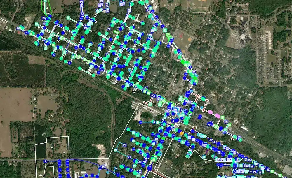
SiteMap® provides an interactive, map-based view of verified underground utilities, helping contractors streamline fiber build-outs and reduce risk.
The Problem
Grid Source’s goal was straightforward: trench, bore, and place fiber across a growing service area.
High Springs, like many communities with public and private development, had mixed information about what was underground. Utility records were inconsistent and, in some cases, dated back decades. Paper as-builts were difficult to interpret and often failed to reflect subsequent repairs, additions, and reroutes. The One Call system had experienced a backlog. This caused locate timelines to stretch past what the construction schedule could handle.
Directional drilling thrives on precision. Without reliable data, the team faced several compounding risks:
- Idle Crews and Disrupted Timelines
When locates lagged and records didn’t agree, crews paused or pivoted to lower-priority tasks. These stop-and-start rhythms increased costs and complexity. - Safety Concerns
A mis-marked or undocumented line is more than a setback; it’s a potential safety incident, a service outage, and a hit to public trust. - Design-by-Guesswork
Engineering decisions hinge on what’s in the ground. Without current, verified as-builts, layout plans become provisional at best. - Communication Gaps
Field teams, project managers, and subcontractors exchanged PDFs, emails, and screenshots. Everyone worked hard, but not always from the same playbook.
The Solution
GPRS verified existing conditions and centralized the project’s underground intelligence inside SiteMap, combining proven field methods with modern software to deliver clarity quickly.
Project Managers mobilized to identify, trace, and mark underground utilities, using advanced locating techniques to ensure accuracy. Where needed, non-destructive daylighting confirmed depths and alignments. The goal was simple: transform uncertainty into documented, field-verified information that the entire team could trust.
Instead of letting verified findings live on paper, the team digitized them. Field notes, photos, and mark-outs were captured and aligned to coordinates, then uploaded to SiteMap. Existing records and as-builts were reviewed and reconciled against verified conditions, allowing discrepancies to be identified early, before they could derail progress.
This approach turned isolated records into a coordinated dataset and gave crews an interactive map they could use in real time.
The Benefits
When you reduce uncertainty, everything else can get easier.
Reduced Downtime
With verified utilities visible in one place, work sequences stabilize. Crews no longer need to wait for scattered updates or long locate queues to start critical path activities. The interactive map that SiteMap offers can help you pinpoint where to proceed confidently and where to adjust plans, minimizing idle time and smoothing schedules.
Improved Safety
Strike risk can drop when your team has better information. Field-verified alignments and depths (where daylighted) give drill operators concrete guidance for bore planning. That clarity, paired with consistent field-to-office communication, can help prevent service interruptions and safeguard people and property.
Easy Adoption
Useful technology is technology your team can actually use. SiteMap is built to be intuitive: open a map, toggle layers, review photos, and access your records. That accessibility means adoption can happen quickly, and the quality of your data can improve steadily as more team members contribute.
Fewer Change Orders
When conflicts surface early because your software shows reality instead of assumptions, design tweaks happen on screen. Potentially leading to reduced rework and the downstream ripple effects that drive costs.
Better Records for the Long Term
The biggest long-term win is the quality of your records. With SiteMap, as-builts are not an afterthought. They’re created as you go, enriched by field verification, and easy to hand off to operations. Months or years down the road, when you return to expand capacity or tie in new routes, you’ll have a reliable record of what’s underground and how it was installed.
What Could This Mean for Your Team?
If your fiber program faces issues like inconsistent as-builts, long locate timelines, or crowded corridors with unmarked utilities, GPRS and SiteMap can help. An interactive approach might change everything for you.
Click below to schedule your live, personal SiteMap demo today!