Transforming Construction Workflows with Interactive Data and Software
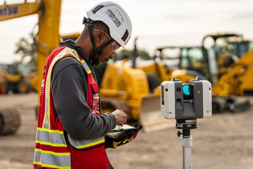
Construction professionals are reaching new levels of precision and productivity with 3D laser scanning. This technology is transforming workflows, from inspection to layout to documentation. It delivers interactive, millimeter-accurate data that helps teams make smarter decisions and avoid costly errors.
Most 3D laser scans typically offer accuracy between 2 and 6 millimeters. That level of detail captures reality in high definition. It also creates a reliable digital record that teams can reference and collaborate on throughout the project.
By combining reality capture with powerful software solutions, like SiteMap®, teams can generate collaborative digital as-builts, streamline layout planning, and maintain comprehensive records, all while improving communication across stakeholders.
3D laser scanning is reshaping construction workflows by delivering precise, interactive data that supports smarter planning and collaboration.
Visualizing Surface Irregularities with Deformation Maps
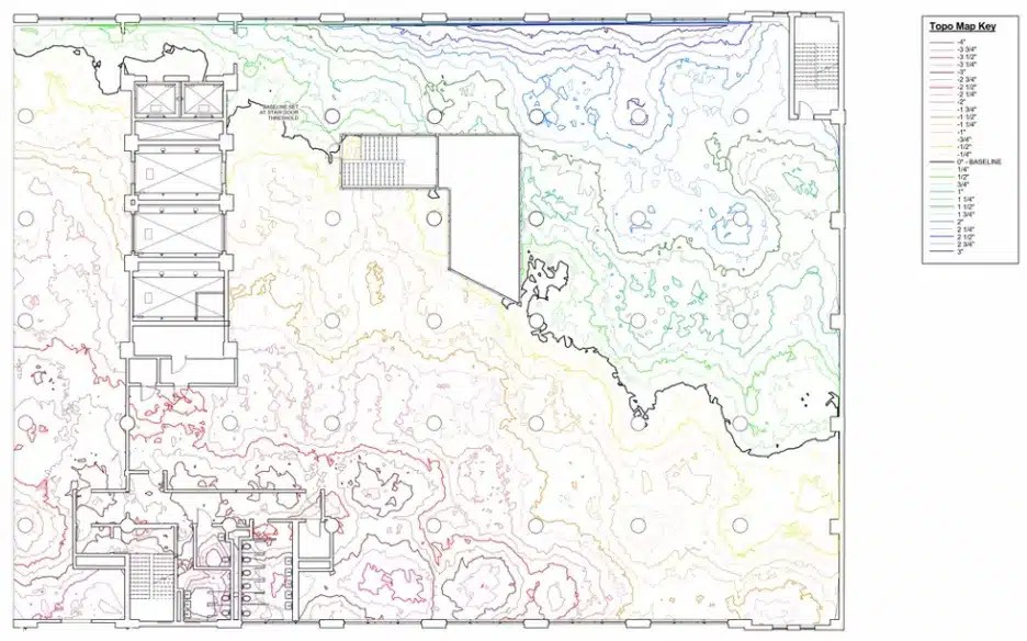
Deformation maps are a powerful, interactive tool used to visualize the topography of built surfaces. Generated from 3D laser scanning data, these color-coded diagrams provide a detailed view of elevation changes across floors, walls, and other structural elements.
Much like a topographic map, deformation maps highlight high and low points using a color spectrum:
- Red, orange, and yellow indicate areas below the baseline.
- Green, blue, and purple show areas above it.
- Black lines represent the baseline reference for measurement.
These maps are essential for identifying uneven floors, evaluating wall deflections, and understanding how weight and load affect structural integrity. They help contractors and engineers:
- Pinpoint elevation deviations that could impact performance or safety.
- Quantify concrete requirements for leveling or correction.
- Track structural changes over time by comparing historical and current scans.
Before the advent of 3D laser scanning, this level of analysis required manual grid-based methods, such as ASTM E1155, which were labor-intensive and prone to human error. Now, with reality capture solutions like those from GPRS, deformation maps can be created quickly and with millimeter-level accuracy. These digital records support smarter planning, reduce rework, and ensure that every decision is backed by precise, visual data.
Deformation maps visualize elevation changes across built surfaces, helping construction teams identify irregularities, plan corrections, and ensure structural integrity with millimeter-level accuracy.
Capturing Every Phase of the Pour with Confidence
Reality capture technology supports concrete pouring projects from start to finish. From pre-pour preparation to post-pour verification, 3D laser scanning ensures that contractors have the data they need to make informed decisions and deliver high-quality results.
Before the pour begins, 3D laser scans document the site’s existing conditions in full detail. This pre-pour asset documentation allows teams to verify that the layout matches engineering plans and ensures that all embedded elements, like post-tension cables, conduit, and rebar, are properly positioned.
Once the concrete is poured and cured to meet strength targets, a second scan can be performed to confirm that the slab aligns with design specifications. After post-tensioning is complete and temporary shoring is removed, a final scan provides contractors and stakeholders with a true collaborative digital as-built of the structure’s existing condition.
Tolerance Checks Made Easy with 3D Laser Scan Data
In construction, precision matters, and being out of tolerance means a structural element has deviated beyond the acceptable range defined in the project specifications. Whether it’s a floor, stair, ramp, or column, even small discrepancies can lead to costly rework or long-term performance issues.
With 3D laser scanning, contractors can quickly and accurately assess whether concrete elements fall within tolerance. The scan data provides quantitative, millimeter-accurate measurements that make it easy to compare actual conditions against design intent.
This level of precision helps teams catch issues early, ensure structural integrity, and maintain compliance with engineering standards.
Prefabrication Made Precise with Reality Capture
Prefabrication offers speed and efficiency and can work seamlessly when accurate. With 3D laser scanning, contractors can document existing structural elements like staircases, walkways, and railing systems, ensuring that prefabricated components fit seamlessly during installation.
Reality capture data collected from the job site can be transformed into detailed 3D BIM models or 2D CAD drawings. These digital assets serve as the foundation for prefabrication workflows, helping teams avoid costly adjustments and delays.
Ensuring ADA Compliance with Construction-Grade Data
ADA compliance is a non-negotiable, and when it comes to ramps and cross slopes, precision is key. These elements must meet strict standards for slope, width, and placement to ensure accessibility and safety.
With 3D laser scanning, contractors can capture accurate point cloud data of ramps and cross slopes, then convert that data into 3D models or 2D drawings. This allows teams to evaluate site conditions with construction-grade accuracy and verify compliance before issues arise.
Store, Share, and Collaborate with SiteMap®
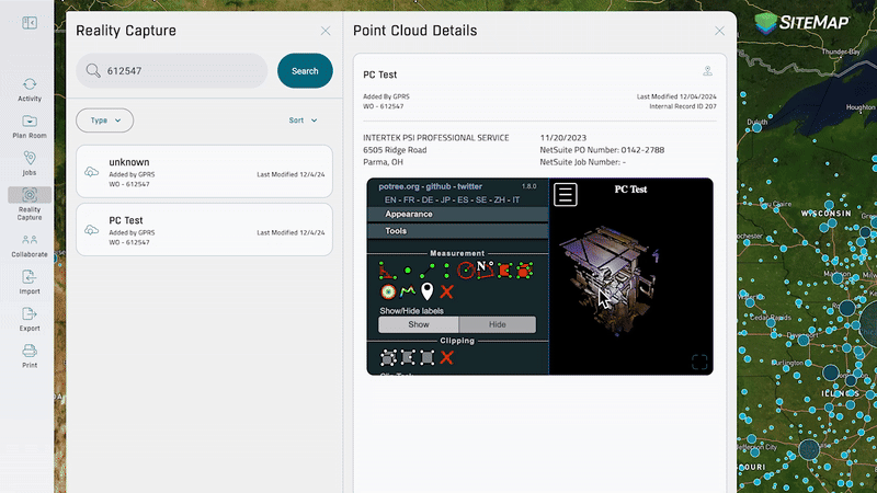
Our updated reality capture features allow you to access and organize virtual tours and point clouds, all in one place. You can filter by file type, search by job details, and interact with your data for a more streamlined experience.
Once your 3D laser scans are complete, SiteMap becomes the central hub for managing and leveraging your data. It transforms them into actionable insights. With SiteMap’s reality capture feature, your team can access high-resolution 3D models, overlay historical and current scans, and integrate data with CAD and BIM tools – all in one place.
Whether you’re tracking structural changes, planning renovations, or verifying ADA compliance, SiteMap keeps your data organized and accessible – so your team can collaborate confidently.
It’s how modern construction teams stay connected, informed, and ahead of schedule.
Click below to schedule your free, personal SiteMap demo today!