
Reality Capture and BIM in SiteMap
Reality capture and Building Information Modeling, or BIM, help teams document, visualize, and manage existing facility conditions. In SiteMap, you can store these deliverables alongside utility maps, 2D CAD drawings, 3D BIM models, reality capture data, virtual tours, drone imagery, video pipe inspection records, and more in one GIS-based platform.
This helps facility managers, contractors, engineers, architects, and owners better understand their sites. You can view your site plans on a desktop, tablet, or mobile device. This way, you can spend less time sorting through separate drawings, PDFs, models, and field notes.
Reality capture documents what exists in the field. BIM organizes the captured data into a structured digital model. SiteMap connects those deliverables so you can measure, share, verify, and use the information throughout planning, construction, renovation, and facility management.
This guide explains how reality capture and BIM work in SiteMap, what deliverables teams can access, and how these tools support safer, more informed decisions across the life of a facility.

The SiteMap® Reality Capture Layer lets you see detailed 3D laser scan data in an interactive way. This helps with accurate analysis and facility management.
Why Reality Capture and BIM Matter
Facilities include both visible and hidden infrastructure. Walls, doors, mechanical rooms, rooflines, floor openings, panels, valves, and structural columns may be easy to see. Underground utilities, outdated as-builts, hidden MEP systems, undocumented renovations, and buried duct banks can be harder to confirm.
Those hidden or incomplete details can affect:
- Design planning
- Utility coordination
- Renovation work
- Excavation safety
- Facility maintenance
- Project handoff
- Long-term asset management
Reality capture helps document those conditions with measurable digital accuracy. Technologies like 3D laser scanning, LiDAR, photogrammetry, drone imagery, and virtual walkthroughs capture real-world conditions and turn them into data that teams can use. GPRS, the nation’s largest private utility locating company, has completed over 300,000 projects nationwide and typically responds to job sites within 48 hours. GPRS reality capture services include 3D laser scanning, point clouds, 2D CAD drawings, 3D BIM models, drone surveys, and virtual tours.
SiteMap helps organize that information so teams can access it when they need it. For facility managers, contractors, engineers, and owners, a scan is only the starting point. SiteMap turns captured data into information your team can measure, share, verify, and use to make faster and safer decisions.
From Field Sketches to Digital As-Builts
Field documentation has come a long way. Still, many project teams rely on paper drawings, hand sketches, marked-up site plans, PDFs, and files scattered across separate folders. Sometimes, those records are the only information available. The challenge is that those records are often outdated, incomplete, or hard to access.
GPRS has moved beyond static field sketches by turning field-collected data into digital deliverables that teams can access in SiteMap. Utility locating data can be collected with GPS, uploaded into SiteMap, and layered with other project information. Reality capture increases visibility by documenting aboveground and indoor conditions. It uses high-density spatial data for accuracy.
A facility map is only useful if it reflects what is actually there. A construction site map only adds value when the people in the field can trust it. SiteMap helps close the gap between field and office teams by providing one central place for current, visual, and accurate site plans.
What Reality Capture Looks Like in SiteMap
Reality capture deliverables in SiteMap generally fall into three core categories: point clouds, virtual walkthroughs, and BIM models.
A point cloud is the raw spatial data collected by laser scanners or photogrammetry. Millions of points represent visible surfaces in a building, room, site, or facility. Each point has spatial coordinates, which allow the dataset to be measured, analyzed, and converted into drawings or models.
A virtual walkthrough gives you an immersive way to move through your space. Instead of driving to the facility to check a panel, doorway, pipe run, or mechanical room, you can open the walkthrough and inspect the space from your computer or mobile device. Virtual walkthroughs support collaboration, documentation, measurement, emergency planning, audits, and remote coordination.
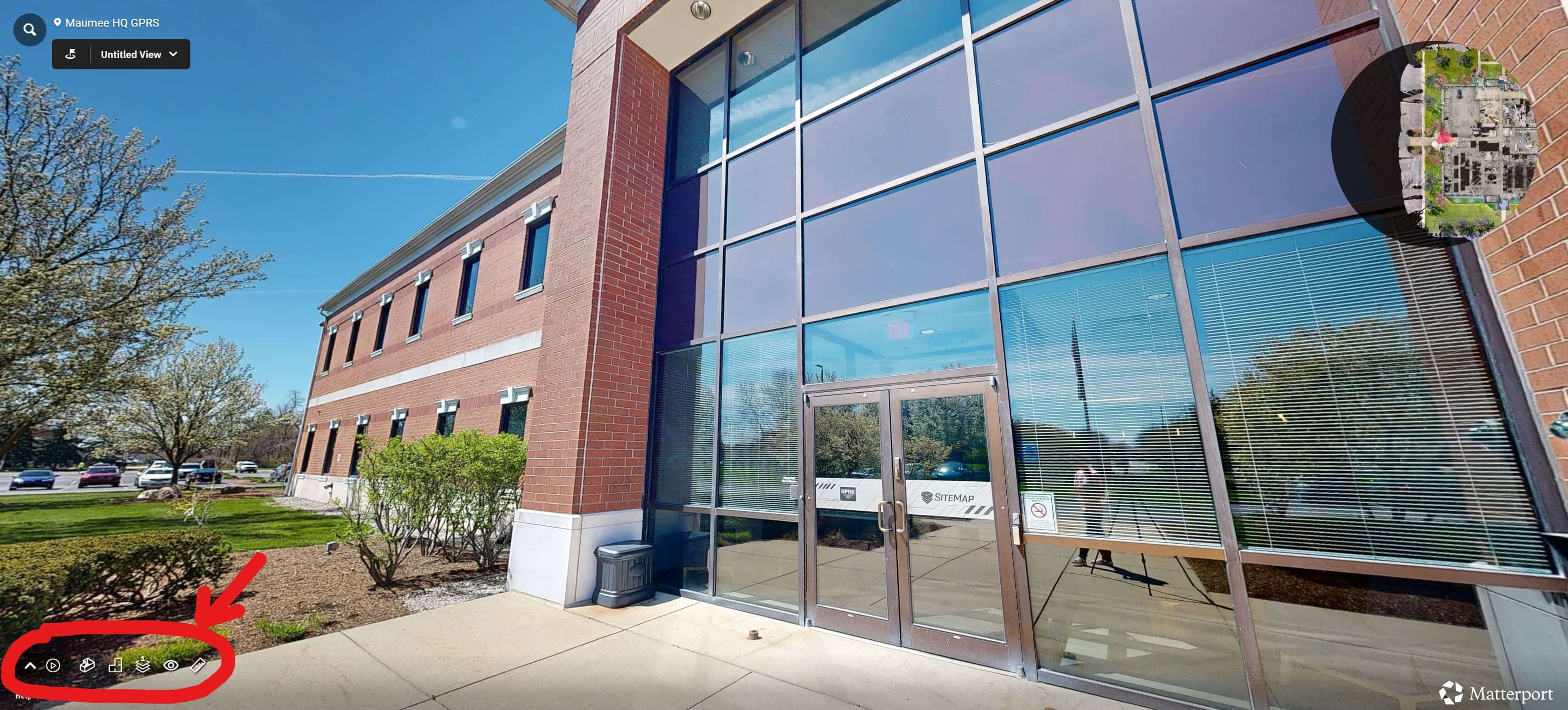
Virtual walkthroughs allow for enhanced collaboration across teams, more efficient project management, accurate documentation, and can even serve as emergency response guides.
A BIM model takes the existing conditions and turns them into a structured digital representation of your facility or site. That model can include architectural, structural, civil, and MEP details depending on the scope. You can access your 3D BIM models in SiteMap, explore building components, and review model layers in a more accessible environment.
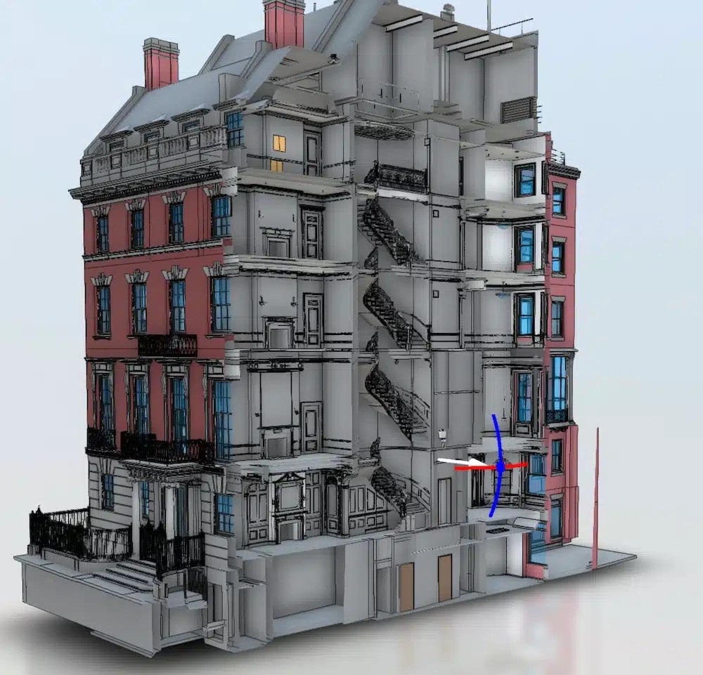
A 3D BIM model in SiteMap helps teams review existing conditions, explore building components, and understand model layers in one secure view.
These deliverables turn SiteMap into more than a storage platform; they provide a practical map for design, construction, maintenance, renovation, and asset management.
Why Access Matters as Much as Accuracy
Different roles on a project rely on the same information in different ways. A BIM coordinator may work directly in the full model. A contractor may review potential conflicts. A facility owner may look at how utilities connect to a building. A maintenance team may focus on locating valves, confirming measurements, or understanding system layouts.
That information often exists in multiple formats and locations. Models, drawings, PDFs, and files can be stored across different systems, which makes it harder to see how everything connects on site.
Most teams need a clear way to view information, take measurements, and understand existing conditions to stay on schedule. Many stakeholders want a clear way to view, measure, and understand the data instead of working directly inside Revit, Civil 3D, Navisworks, or point cloud software.
SiteMap brings these data types together into a single, accessible view. Teams can open a site, turn on the layers they need, and see how models, drawings, and field data relate in one place.
This approach supports more consistent decision-making, reduces repeat site visits, and keeps teams aligned as conditions, designs, and projects move forward.
Matching the Capture Method to the Job
Every project has different documentation needs. The right capture method depends on the level of detail your team needs, the size of the site, and how you will use the information after collection.
A virtual walkthrough supports general visualization, remote site reviews, emergency planning, and basic measurements. These walkthroughs give teams a fast way to review facility conditions from a desktop, tablet, or mobile device.
Terrestrial laser scanning supports projects that need higher precision. Laser scanning uses LiDAR to collect spatial data. This data is useful for modeling, prefabrication, renovation planning, clash detection, and producing construction-grade as-builts. Depending on the site, equipment, and deliverable requirements, GPRS’ LiDAR-based 3D laser scanning services typically achieve tolerances in the 2 to 4mm range.
Drone imagery supports larger exterior sites. A drone captures the full site from above. This includes rooftops, pavement, laydown areas, utility markings, access roads, and building footprints.
Each capture method serves a different purpose:
- Virtual walkthroughs help teams see and review a space remotely
- 3D laser scanning supports precise measurement and detailed modeling
- Drone imagery provides current visual context across larger sites
- Point clouds preserve measurable spatial data from the field
- BIM models organize captured conditions into a structured digital format
When these methods work together, you gain a complete view of your site, from the construction site map down to detailed building conditions.
How Reality Capture Works with Underground Utility Mapping Software
Facilities operate as connected systems. Buildings, utilities, site infrastructure, and maintenance records affect your project planning and completion.
Utility systems often extend across a site and connect directly to buildings. Water, storm, sanitary, electrical, gas, communications, and other facility systems can all affect excavation, drilling, renovation, expansion, and maintenance work.
SiteMap connects this information by bringing underground utility maps together with reality capture, BIM models, drawings, and drone imagery. Teams can view underground and aboveground information in the same place instead of switching between separate files and systems.
This connected view supports clearer coordination. A team reviewing a building expansion can open the facility map, turn on underground utility layers, review the construction site map, open a virtual walkthrough, view the point cloud, and reference the BIM model in one place.
This workflow helps you understand how systems relate to each other before work begins. You can review a proposed foundation element, utility tie-in, or trench route against existing infrastructure.
Coordination improves when information is visible and connected. You can review conditions, compare design intent with existing infrastructure, and make decisions based on what is actually there.
How Point Clouds Become BIM Models
Point clouds capture detailed spatial information from the field. They represent visible surfaces with millions of data points, giving teams the existing conditions.
That raw data becomes more useful when it is converted into drawings and models. The scan to BIM process turns point cloud data into structured deliverables that support design, construction, renovation, prefabrication, and facility management.
Depending on the project scope, point cloud data can be used to create 2D CAD drawings, 3D models, and interactive virtual walkthroughs for visualization, analysis, design, construction, renovation, prefabrication, and facility modifications.
How Reality Capture Supports the Project Life Cycle
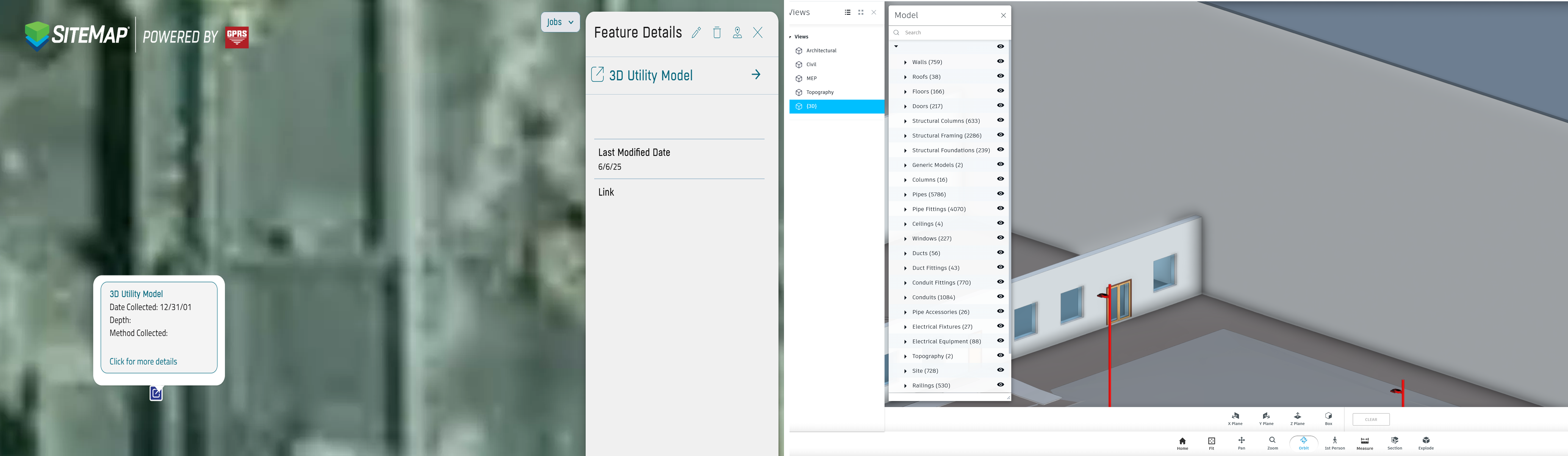
With the SiteMap® Reality Capture Layer, you can view geolocated 3D utility models alongside detailed Revit building components for complete visualization and data management.
Reality capture and BIM provide value across the full life of a project. The same information collected early can continue to support design, construction, handoff, operations, and future renovations.
During planning and design, accurate existing conditions give you a stronger starting point. You can use that data to understand existing building conditions, confirm dimensions, review access constraints, build accurate floor plans, and support early design decisions.
During pre-construction, reality capture helps you compare proposed work with existing site conditions. Models, point clouds, and utility maps can be reviewed together to support design verification, clash review, utility coordination, access planning, scope clarification, and construction sequencing.
During construction, SiteMap can support documentation as conditions change. Utility data, drone imagery, updated drawings, and model revisions help teams keep a clear record of what is installed and where it is located. This creates a stronger project record during active work, especially before utilities, structural elements, or MEP systems are covered, buried, paved over, or enclosed.
A connected facility map or building map can support maintenance planning, future renovations, emergency response, asset management, space planning, utility coordination, and facility audits. And all the data collected during design and construction will continue to support the facility long after the project is complete.
How Facility Teams Use This Data
Facility teams make decisions every day using the information available to them. The quality, accuracy, and accessibility of that information directly affect how well the work gets done.
A facility team may need to know where the nearest shutoff is located, what utilities serve a building, what systems run through a specific area, where access points are located, what changed during the last renovation, or which drawing reflects current conditions.
SiteMap helps organize those answers by bringing facility records into one connected environment. This gives internal teams, contractors, and service providers a clearer view of the facility before work begins. A building map becomes a working reference for planning, maintenance, response, and long-term operations.
Accurate floor plans also support space management by giving facility and real estate teams a better understanding of square footage, occupancy, and building use.
Bringing It All Together
Reality capture documents existing conditions. BIM organizes those conditions into structured models. SiteMap connects the information so teams can use it in one place.
Point clouds provide measurable spatial data. Virtual walkthroughs give teams visual access to captured spaces. BIM models support coordination, planning, and design review. Utility layers show what is below ground. Drone imagery adds broader site context. Facility records preserve historical and operational information.
Together, these tools create a clearer picture of your built environment. You can see what exists, understand how systems interact, and work from the same information as projects move forward.
How SiteMap Turns Reality Capture Into Usable Data
Reality capture and BIM give teams a clearer way to understand existing conditions.
The process starts with field capture. A scan documents what is visible. A point cloud preserves measurable spatial data. A BIM model organizes that information into a structured format. SiteMap connects those deliverables with utility maps, drawings, drone imagery, virtual walkthroughs, and facility records so you can use the information after fieldwork is complete.
This makes the data easier to apply in real situations. You can review, compare, check, and understand how systems connect before work begins.
For construction teams, this supports clearer coordination. For facility teams, this creates a more reliable record for maintenance and renovations. For owners, this builds a stronger digital foundation for future planning.
Reality capture and BIM are most useful when the information is accessible, measurable, and connected to the larger facility record. SiteMap provides that connection by bringing field data, models, and maps into one place where teams can review the past, understand the present, and plan the next step with confidence.
Click the button below to create a free SiteMap account to start organizing your reality capture, BIM, and utility data in one place.
Frequently Asked Questions
Is SiteMap GIS Software free?
Every GPRS project includes a complimentary SiteMap Personal subscription, allowing you to view, download, and share all your GPRS-captured data. For expanded usage such as historical data aggregation, additional users, and advanced features, we offer upgraded subscriptions: SiteMap Project, SiteMap Pro, and SiteMap Team. Each option is tailored to different user needs. To learn more about SiteMap’s abilities and subscription levels, contact support@sitemap.com for more information.
Can I export SiteMap data into Esri platforms?
Yes. SiteMap supports data portability in formats like Shapefile and GeoJSON, making it easy to import accurate utility and mapping data into ArcGIS and other Esri workflows. This ensures your team can integrate SiteMap deliverables into your existing GIS environment without disruption.
Can SiteMap scale as my portfolio grows?
Yes. SiteMap is designed to scale with your needs. Whether you manage a single facility or a nationwide portfolio, the platform brings your plans into one interactive system. You can continue adding new projects using the same workflow, allowing you to grow without changing your process. To learn more about SiteMap’s abilities and subscription levels, contact support@sitemap.com for more information.