Stay in Control of Your Facility
You need accurate, accessible information to manage your facilities. SiteMap® provides one secure source of truth for your building and utility plans. You have the information you need when you need it. This helps you stay organized, improve efficiency, and keep operations running.
Augmented Reality

Augmented Reality

My Dig Board
My Dig Board
Customer Self‑Service Form

Customer Self‑Service Form
99% Accurate Utility Data
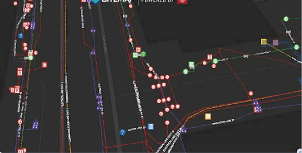
Access layered, interactive underground utility maps, PDFs, and KMZ files 24/7
Feature Renaming
Rename features with labels your team uses so your maps make sense at a glance.
History Slider
Scroll through past data to spot duplicates and see how your site has changed over time.
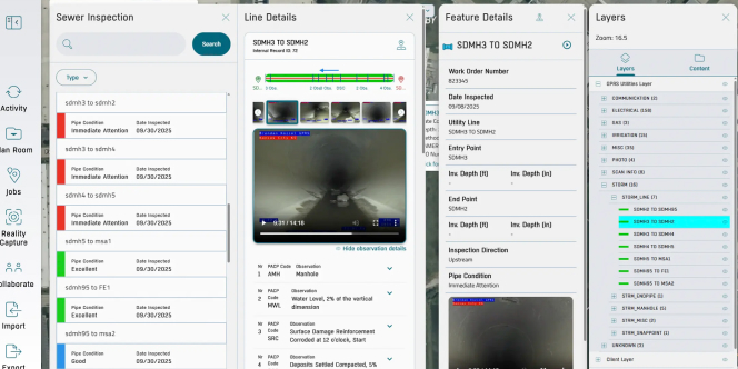
Sewer System Mapping
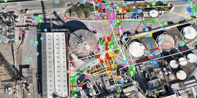
99% Accurate Utility Data
Access your utility maps 24/7.
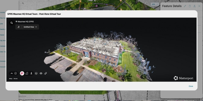
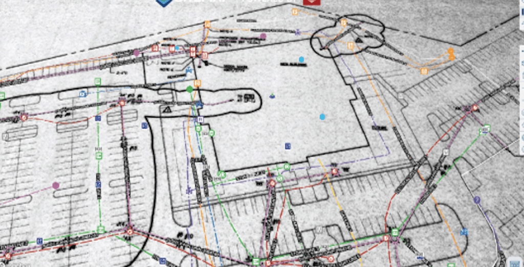
Reality Capture
Visualize your assets from anywhere to support collaboration.
99% Accurate Utility Data
Access layered, interactive underground utility maps, PDFs, and KMZ files 24/7
Feature Renaming
Rename features with labels your team uses so your maps make sense at a glance.
History Slider
Scroll through past data to spot duplicates and see how your site has changed over time.
Sewer System Mapping
99% Accurate Utility Data
Access your utility maps 24/7.
Reality Capture
Visualize your assets from anywhere to support collaboration.
Why Teams Choose SiteMap
Here’s what our clients say about using SiteMap for accurate utility data and job site planning.
“SiteMap has been a big part of it for us — to avoid and eliminate potential risks, liabilities, or damages on the job.”
Hunt Moss
“The main benefit of SiteMap is having all of the information stored in one location that everybody can access.”
Brasfield & Gorrie, LLC
“The definition, the detail you provide with SiteMap’s data is just so much better than anything we’ve had.”
The University of Toledo

Above, Below, & Beyond
- 99.8% Accurate Utility Data: Access your utility maps 24/7
- Historical Data & Drone Imagery: Trackchanges overtime for planning
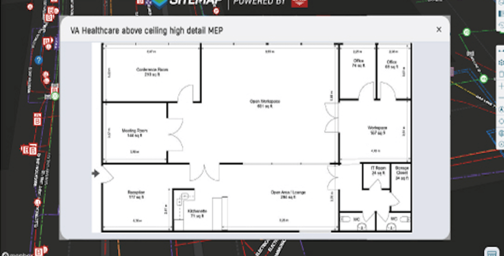
- Geolocated Floor Plans & Emergency Routes: Improvesafety and response times with critical building details at your fingertips
- Reality Capture: 3D Models & Virtual Tours: Visualizeyour assets from anywhere to support collaboration
- Construction Progress Tracking & Open Trench Photos: Stay on schedule and budget with real-time project monitoring
- Sewer Layer & NASSCO Condition Assessments: Gain full visibility into your sewer systems to focus on repairs, extend asset life, and prevent costly surprises
Above, Below, & Beyond
- 99.8% Accurate Utility Data: Access your utility maps 24/7
- Historical Data & Drone Imagery: Trackchanges overtime for planning
- Geolocated Floor Plans & Emergency Routes: Improvesafety and response times with critical building details at your fingertips
- Reality Capture: 3D Models & Virtual Tours: Visualizeyour assets from anywhere to support collaboration
- Construction Progress Tracking & Open Trench Photos: Stay on schedule and budget with real-time project monitoring
- Sewer Layer & NASSCO Condition Assessments: Gain full visibility into your sewer systems to focus on repairs, extend asset life, and prevent costly surprises
Experience Your Site in a New Way
Tell us more about your facility, and we will show you what SiteMap can do for you.